Maps of the Turks and Caicos Islands
A selection of maps showing the location of the Turks and Caicos Islands in the Caribbean, details of the Turks and Caicos Islands and very detailed maps of Providenciales (Provo), North Caicos and Middle Caicos.
-
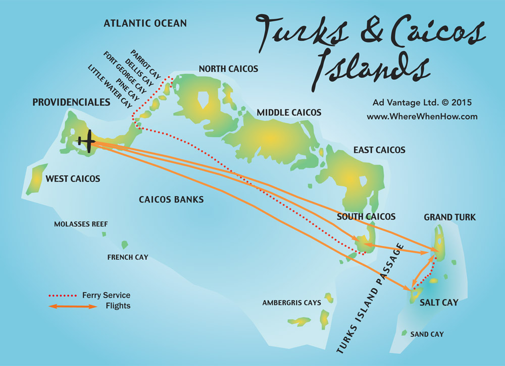
Caribbean Location of the Turks & Caicos Islands
The Turks & Caicos Islands are located 575 miles (926km) southeast of Miami, Florida. The islands lie just south of the Bahamas archipelago and 90 miles (145km) north of Hispaniola. The low-lying land masses feature green hills rising to a maximum of 250 feet (77m). Completely surrounded and protected by the Caribbean’s largest and healthiest coral reef system - tropical fish abound.
View a larger version of this Caribbean map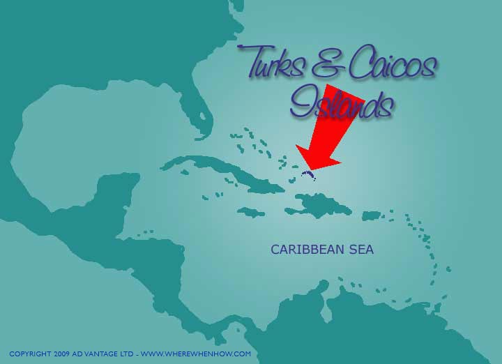 Map Showing the Location of the Turks & Caicos Islands in the Caribbean
 -
Map of the Turks and Caicos Islands
The Turks & Caicos Islands were already well known by scuba divers and are becoming more well known as an upscale romantic vacation destination. Grace Bay Beach has been voted as one of the best beaches in the world for several years.
View a larger version of this Turks & Caicos Islands map Map of the Turks and Caicos Islands
 -
Map of Providenciales (Provo), Turks & Caicos Islands
The most developed of the Turks and Caicos’ eight inhabited islands, Providenciales (Provo) is just 23 miles (37km) long by 4 miles (6.5km) wide. The talcum-powder soft white sand of Grace Bay Beach runs along the north shore for more than 7 miles (11km).
View a much larger (1.3 MB) version of this Providenciales (Provo) mapView and optionally print (2 page spread) a large (0.5 MB) PDF version of this Providenciales (Provo) map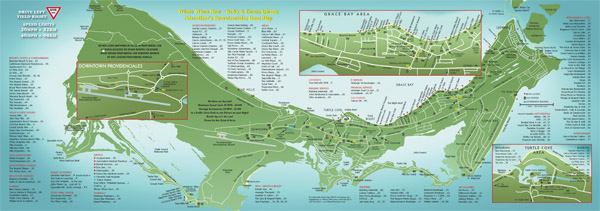 Map of Providenciales (Provo) in the Turks & Caicos Islands
 -
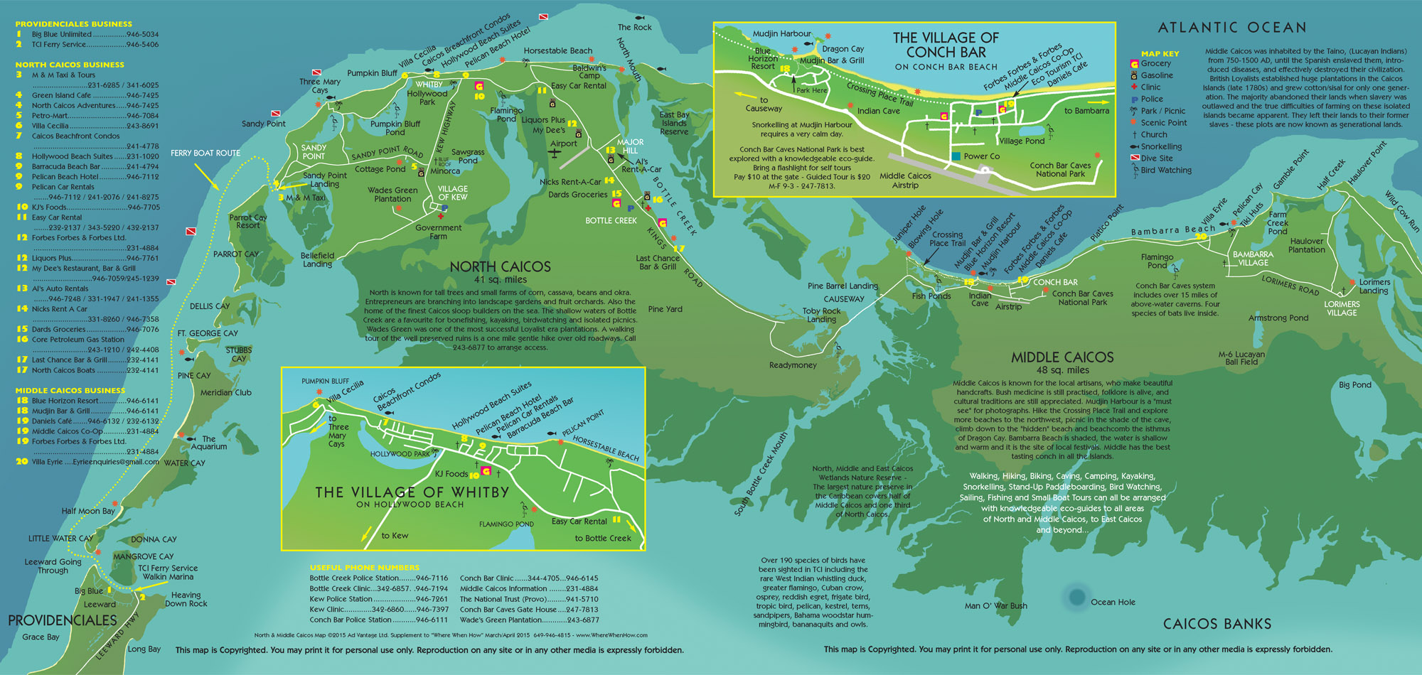
Map of North Caicos and Middle Caicos
North Caicos at 41 sq miles (66 sq kms) is often referred to as The Garden Island of the Turks and Caicos. With approximately 2,500 year round inhabitants, transportation to the island is by TCI Ferry (passenger only) service from Providenciales. Once you are on North Caicos it is an easy drive across the causeway to Middle Caicos. The largest of the islands, Middle Caicos is 48 sq miles (77 sq kms) yet boasts a population of just 300 people!
View a larger version of this North Caicos and Middle Caicos mapView and optionally print (2 pages) a large PDF version of this North Caicos and Middle Caicos map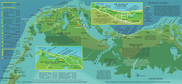 Map of North Caicos and Middle Caicos in the Turks & Caicos Islands
 -
Map of Grand Turk
Grand Turk makes up in stature what it lacks in size. At barely seven square miles, (6.5 long and 1.5 wide), it is the capital island of the Turks & Caicos. The only settlement, Cockburn Town, is home to several excellent examples of Bermudan architecture and the Turks & Caicos National Museum. Cruise ships dock at the Grand Turk Cruise Center.
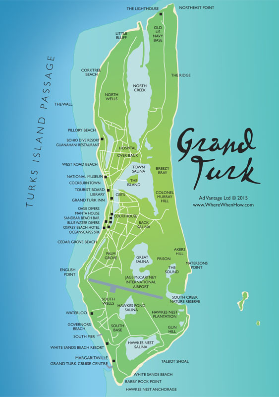 Map of Grand Turk in the Turks & Caicos Islands
 -
Map of Salt Cay
As small as it is, Salt Cay IS the second largest of the Turks Islands. Triangular in shape, each coastline is barely two miles long and there are fewer than 100 full-time residents. In the 1700s, it boasted a thriving salt industry. The demise of that economy, in about 1930, saw the island’s population decline steadily. Today, Salt Cay is renowned for fabulous whale watching encounters, both in and out of the water, miles of pristine, deserted white sand beaches, small town friendliness, and very fresh local seafood. This is the perfect island for nature buffs, cyclers, snorkellers and SCUBA divers, and for those who just wish to relax and unwind. Charter flights are available.
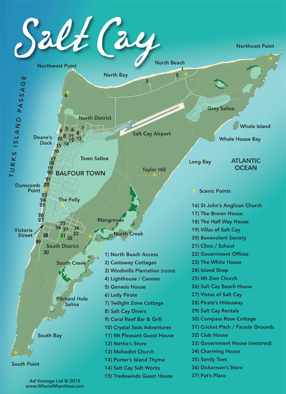 Map of Salt Cay in the Turks & Caicos Islands
 -
Map of South Caicos
South Caicos, despite its relatively unknown status in the current tourism hierarchy, is an eden for eco-tourists, fishing and water sports adherents. The landscape and waterscapes of this 8.5 square mile island are sweeping, and the beaches untouched. Several luxury, yet ecologically friendly homes have been built and more are planned. A new resort opened in 2015. There are approximately 1,100 residents on South. Visit the Big South via TCI Ferry service or InterCaribbean flights from Providenciales.
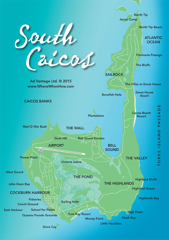 Map of South Caicos in the Turks & Caicos Islands
Related Topics
- The Best Turks and Caicos Restaurants, Cafés and Bars
- Turks and Caicos Shopping Guide
- The Best Turks and Caicos Hotels, Resorts and Villas
- Caribbean Villas For Rent By Owner
- Turks & Caicos Weather Forecast, Water Temperature, Climate and Rainfall Charts
- Turks & Caicos Things To Do - Tours, Sports, Water Sports, Fishing, Golf, Entertainment
- Turks & Caicos Things To Do: Stand Up Paddleboarding (SUP)